Tiedosto:2020 US House Election Results.svg

Tämän PNG-esikatselun koko koskien SVG-tiedostoa: 800 × 379 kuvapistettä. Muut resoluutiot: 320 × 152 kuvapistettä | 640 × 303 kuvapistettä | 1 024 × 485 kuvapistettä | 1 280 × 607 kuvapistettä | 2 560 × 1 214 kuvapistettä | 1 521 × 721 kuvapistettä.
Alkuperäinen tiedosto (SVG-tiedosto; oletustarkkuus 1 521 × 721 kuvapistettä; tiedostokoko 2,23 MiB)
| Tämä tiedosto on tiedostotietokanta Wikimedia Commonsista. Tiedot kuvaussivulta näkyvät alla. |  |
Tiedoston kuvaussivu Commonsissa |
Yhteenveto
| Kuvaus |
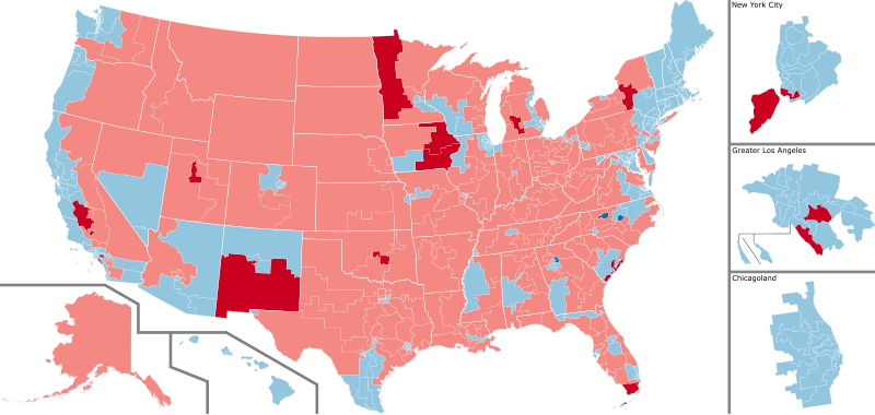
English: A map of the US house districts, color coded by party affiliation of the winner, with information on whether the seat was flipped (darker color) or is still uncalled (grey).
Democratic hold
Republican hold Democratic gain
Republican gain Results and uncalled races per the New York Times, current as of last edit |
| Päiväys | |
| Lähde | Oma teos |
| Tekijä | Infinitesimall |
Lisenssi
| This map is ineligible for copyright and therefore in the public domain, because it consists entirely of information that is common property and contains no original authorship. For more information, see Commons:Threshold of originality § Maps.
|
Though this map is believed to be in the public domain, it was released under the following license:
Minä, tämän teoksen tekijänoikeuksien haltija, julkaisen täten tämän teoksen seuraavalla lisenssillä:
Tämä tiedosto on lisensoitu Creative Commons Nimeä-JaaSamoin 4.0 Kansainvälinen -lisenssillä.
- Voit:
- jakaa – kopioida, levittää ja esittää teosta
- remiksata – valmistaa muutettuja teoksia
- Seuraavilla ehdoilla:
- nimeäminen – Sinun on mainittava lähde asianmukaisesti, tarjottava linkki lisenssiin sekä merkittävä, mikäli olet tehnyt muutoksia. Voit tehdä yllä olevan millä tahansa kohtuullisella tavalla, mutta et siten, että annat ymmärtää lisenssinantajan suosittelevan sinua tai teoksen käyttöäsi.
- jaa samoin – Jos muutat tai perustat tähän työhön, voit jakaa tuloksena syntyvää työtä vain tällä tai tämän kaltaisella lisenssillä.
Tiedoston historia
Päiväystä napsauttamalla näet, millainen tiedosto oli kyseisellä hetkellä.
| Päiväys | Pienoiskuva | Koko | Käyttäjä | Kommentti | |
|---|---|---|---|---|---|
| nykyinen | 8. helmikuuta 2021 kello 23.19 | | 1 521 × 721 (2,23 MiB) | CoasterEnthusiast18 | Anthony Brindisi conceded, NY-22 flip |
| 12. tammikuuta 2021 kello 03.29 |  | 1 521 × 721 (2,23 MiB) | Ketrit | AP calls IA-02 for Miller-Meeks. | |
| 7. tammikuuta 2021 kello 02.49 |  | 1 521 × 721 (2,23 MiB) | Ketrit | Fixed colors and added state borders. | |
| 7. joulukuuta 2020 kello 16.33 |  | 512 × 249 (2,53 MiB) | DoctorWho70 | The AP and NYT have called NY-1 and NY-2. | |
| 2. joulukuuta 2020 kello 18.20 |  | 624 × 303 (2,53 MiB) | DoctorWho70 | The Associated Press has called CA-25, NY-11, and NY-24. | |
| 2. joulukuuta 2020 kello 18.10 |  | 624 × 303 (2,53 MiB) | DoctorWho70 | Reverted to version as of 23:27, 29 November 2020 (UTC) | |
| 2. joulukuuta 2020 kello 18.09 |  | 512 × 512 (2,55 MiB) | DoctorWho70 | The AP has called CA-21, NY-11, and NY-24. | |
| 30. marraskuuta 2020 kello 02.27 |  | 624 × 303 (2,53 MiB) | Wollers14 | There can be only updates to the map IF and only IF the AP calls them. The text is different because it requires either an AP call or a concession. The map does not have the concession requirement and only relies on AP calls. | |
| 29. marraskuuta 2020 kello 19.59 |  | 624 × 303 (2,53 MiB) | Ngfsmg | Reverted to version as of 16:14, 29 November 2020 (UTC) Someone can correct Ca-21 (I don't know how to do it), but we can't have districts called in the text and than say they aren't called in the image | |
| 29. marraskuuta 2020 kello 19.32 |  | 624 × 303 (2,53 MiB) | Wollers14 | Reverted to version as of 17:36, 28 November 2020 (UTC) You reverted CA 21 and the map will be updated as the AP makes the calls. |
Tiedoston käyttö
Seuraava sivu käyttää tätä tiedostoa:
Tiedoston järjestelmänlaajuinen käyttö
Seuraavat muut wikit käyttävät tätä tiedostoa:
- Käyttö kohteessa bn.wikipedia.org
- Käyttö kohteessa de.wikipedia.org
- Käyttö kohteessa el.wikipedia.org
- Käyttö kohteessa en.wikipedia.org
- Käyttö kohteessa es.wikipedia.org
- Käyttö kohteessa fa.wikipedia.org
- Käyttö kohteessa fr.wikipedia.org
- Käyttö kohteessa it.wikipedia.org
- Käyttö kohteessa ko.wikipedia.org
- Käyttö kohteessa nl.wikipedia.org
- Käyttö kohteessa pt.wikipedia.org
- Käyttö kohteessa ru.wikipedia.org
- Käyttö kohteessa simple.wikipedia.org
- Käyttö kohteessa vi.wikipedia.org
- Käyttö kohteessa zh.wikipedia.org