Tiedosto:1973 sinai war maps.jpg

Alkuperäinen tiedosto (1 165 × 894 kuvapistettä, 217 KiB, MIME-tyyppi: image/jpeg)
| Tämä tiedosto on tiedostotietokanta Wikimedia Commonsista. Tiedot kuvaussivulta näkyvät alla. |  |
Tiedoston kuvaussivu Commonsissa |
Yhteenveto
| Kuvaus |
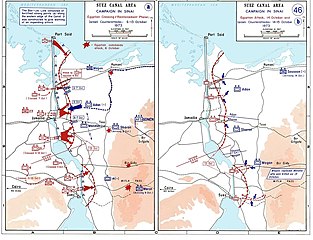
العربية: خريطة للتحركات العسكرية على الجبهة المصرية في حرب أكتوبر في الفترة بين 6 و 13 أكتوبر.
English: Sinai maps, from the US Military Academy History archives (copyright US government?)
Background information: In 1938 the predecessors of what is today The Department of History at the United States Military Academy began developing a series of campaign atlases to aid in teaching cadets a course entitled, "History of the Military Art." Since then, the Department has produced over six atlases and more than one thousand maps, encompassing not only America’s wars but global conflicts as well. In keeping abreast with today's technology, the Department of History is providing these maps on the internet as part of the department's outreach program. The maps were created by the United States Military Academy’s Department of History and are the digital versions from the atlases printed by the United States Defense Printing Agency. We gratefully acknowledge the accomplishments of the department's former cartographer, Mr. Edward J. Krasnoborski, along with the works of our present cartographer, Mr. Frank Martini. Please be aware that these maps are large in file size and may require substantial download times.. |
| Päiväys | 2005-04-220 |
| Lähde |
|
| Tekijä | Ondrejk |
| Muut versiot |
 |
Tämän kuvan on ottanut tai tehnyt Yhdysvaltain liittovaltion armeijan sotilas tai työntekijä virallisia velvollisuuksiansa suorittaessaan. Yhdysvaltain liittovaltion viranomaisten työntekijöiden tekemät teokset eivät saa tekijänoikeuden suojaa Yhdysvaltain tekijänoikeuslain 105 § mukaisesti.
|
 |
Downloaded and copied from EN-wiki
Tiedoston historia
Päiväystä napsauttamalla näet, millainen tiedosto oli kyseisellä hetkellä.
| Päiväys | Pienoiskuva | Koko | Käyttäjä | Kommentti | |
|---|---|---|---|---|---|
| nykyinen | 2. kesäkuuta 2009 kello 00.06 | | 1 165 × 894 (217 KiB) | Hohum | Cleaned up |
| 20. huhtikuuta 2005 kello 21.09 |  | 1 165 × 894 (174 KiB) | Thuresson | larger size | |
| 20. huhtikuuta 2005 kello 20.56 |  | 1 000 × 765 (63 KiB) | Ondrejk | Sinai maps, from the US Military Academy History archives (copyright US government?) Source: Department of History, U.S. Military Academy {{PD-USGov}} Downloaded and copied from EN-wiki |
Tiedoston käyttö
Seuraava sivu käyttää tätä tiedostoa:
Tiedoston järjestelmänlaajuinen käyttö
Seuraavat muut wikit käyttävät tätä tiedostoa:
- Käyttö kohteessa af.wikipedia.org
- Käyttö kohteessa ast.wikipedia.org
- Käyttö kohteessa bg.wikipedia.org
- Käyttö kohteessa ca.wikipedia.org
- Käyttö kohteessa cy.wikipedia.org
- Käyttö kohteessa da.wikipedia.org
- Käyttö kohteessa de.wikipedia.org
- Käyttö kohteessa el.wikipedia.org
- Käyttö kohteessa en.wikipedia.org
- Käyttö kohteessa eo.wikipedia.org
- Käyttö kohteessa es.wikipedia.org
- Käyttö kohteessa eu.wikipedia.org
- Käyttö kohteessa fr.wikipedia.org
- Käyttö kohteessa gl.wikipedia.org
- Käyttö kohteessa he.wikipedia.org
- Käyttö kohteessa id.wikipedia.org
- Käyttö kohteessa it.wikipedia.org
- Käyttö kohteessa it.wikibooks.org
- Käyttö kohteessa ja.wikipedia.org
- Käyttö kohteessa jv.wikipedia.org
- Käyttö kohteessa lv.wikipedia.org
- Käyttö kohteessa ms.wikipedia.org
- Käyttö kohteessa ne.wikipedia.org
- Käyttö kohteessa nl.wikipedia.org
- Käyttö kohteessa nn.wikipedia.org
- Käyttö kohteessa no.wikipedia.org
- Käyttö kohteessa pl.wikipedia.org
Näytä lisää tämän tiedoston järjestelmänlaajuista käyttöä.