Tiedosto:1970 I-485-map.jpg

Tämän esikatselun koko: 593 × 599 kuvapistettä. Muut resoluutiot: 237 × 240 kuvapistettä | 475 × 480 kuvapistettä | 760 × 768 kuvapistettä | 1 013 × 1 024 kuvapistettä | 2 027 × 2 048 kuvapistettä | 3 317 × 3 352 kuvapistettä.
Alkuperäinen tiedosto (3 317 × 3 352 kuvapistettä, 1,45 MiB, MIME-tyyppi: image/jpeg)
| Tämä tiedosto on tiedostotietokanta Wikimedia Commonsista. Tiedot kuvaussivulta näkyvät alla. |  |
Tiedoston kuvaussivu Commonsissa |
Yhteenveto
| Kuvaus |
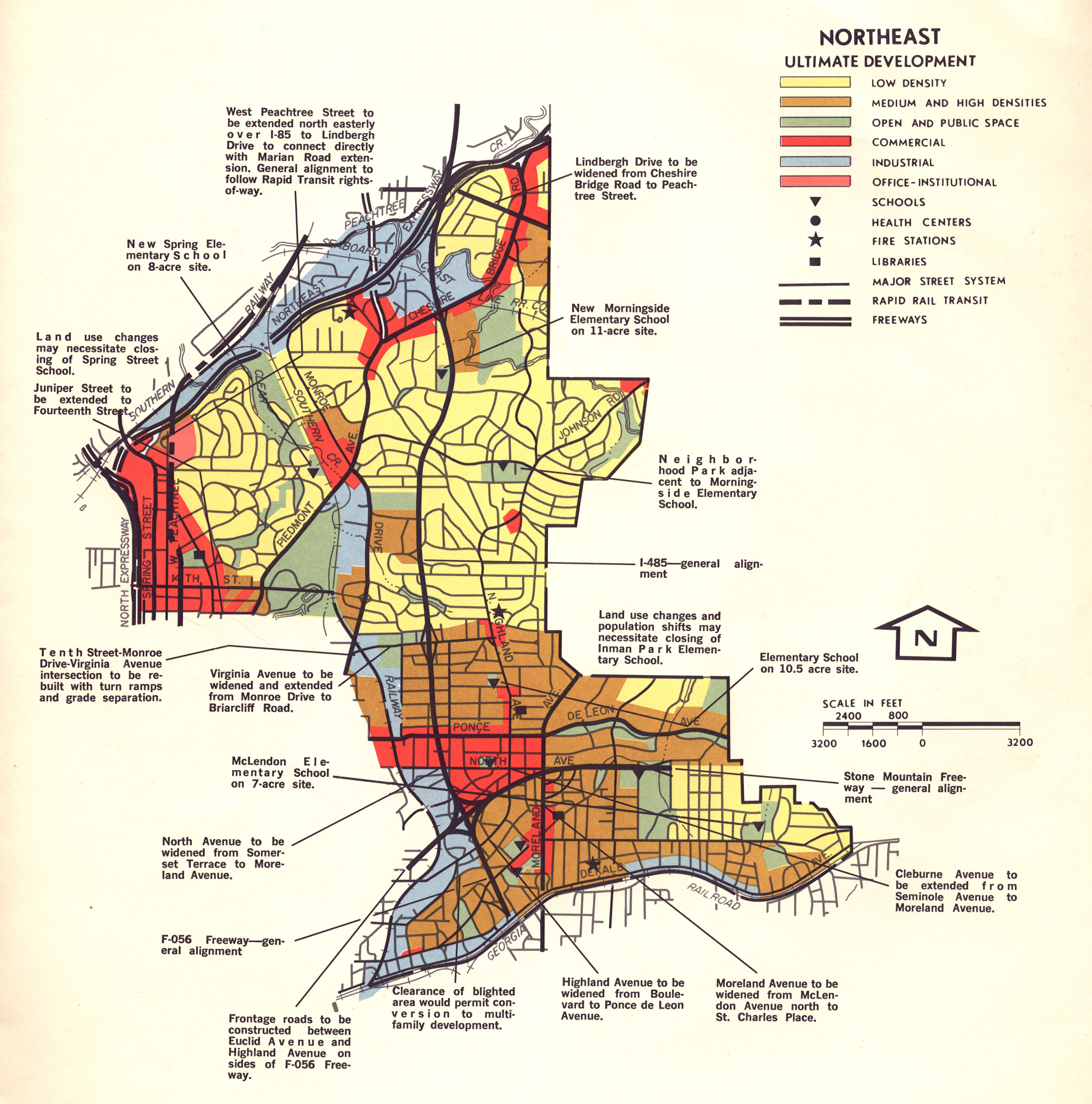
English: Proposed route of I-485 through northeastern part of the City of Atlanta in 1970. |
| Päiväys | |
| Lähde | http://vahi.org/wp-content/uploads/2012/04/1970_I-485-map.jpg |
| Tekijä | Georgia Dept of Transportation |
Lisenssi
This work is in the public domain in the United States because it was published in the United States between 1929 and 1977, inclusive, without a copyright notice. For further explanation, see Commons:Hirtle chart as well as a detailed definition of "publication" for public art. Note that it may still be copyrighted in jurisdictions that do not apply the rule of the shorter term for US works (depending on the date of the author's death), such as Canada (50 p.m.a.), Mainland China (50 p.m.a., not Hong Kong or Macao), Germany (70 p.m.a.), Mexico (100 p.m.a.), Switzerland (70 p.m.a.), and other countries with individual treaties.
|
 |
Tiedoston historia
Päiväystä napsauttamalla näet, millainen tiedosto oli kyseisellä hetkellä.
| Päiväys | Pienoiskuva | Koko | Käyttäjä | Kommentti | |
|---|---|---|---|---|---|
| nykyinen | 24. huhtikuuta 2012 kello 18.44 | | 3 317 × 3 352 (1,45 MiB) | Keizers |
Tiedoston käyttö
Seuraava sivu käyttää tätä tiedostoa:
Tiedoston järjestelmänlaajuinen käyttö
Seuraavat muut wikit käyttävät tätä tiedostoa:
- Käyttö kohteessa en.wikipedia.org
- Käyttö kohteessa www.wikidata.org