Tiedosto:Wright Brothers Memorial-27527-1.JPG

Tämän esikatselun koko: 600 × 600 kuvapistettä. Muut resoluutiot: 240 × 240 kuvapistettä | 480 × 480 kuvapistettä | 768 × 768 kuvapistettä | 1 024 × 1 024 kuvapistettä | 1 600 × 1 600 kuvapistettä.
Alkuperäinen tiedosto (1 600 × 1 600 kuvapistettä, 545 KiB, MIME-tyyppi: image/jpeg)
| Tämä tiedosto on tiedostotietokanta Wikimedia Commonsista. Tiedot kuvaussivulta näkyvät alla. |  |
Tiedoston kuvaussivu Commonsissa |
Yhteenveto
| Kuvaus |
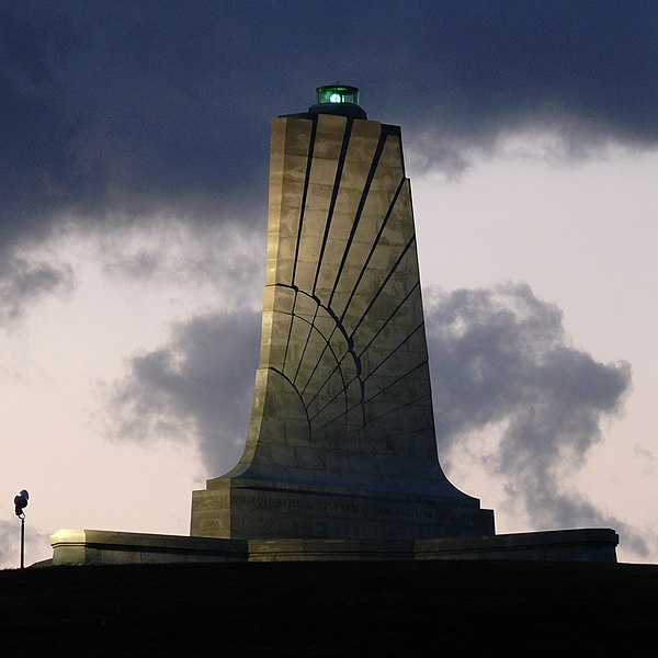
Standing sixty feet (18.3 meters) tall and perched atop a ninety foot (27.4 meters) stabilized sand dune known as Kill Devil Hill, this monument towers over Wright Brothers National Memorial Park in Kill Devil Hills, NC. The park commemorates and preserves the site where the Wright brothers launched the world's first successful sustained, powered flights in a heavier-than-air machine. The inscription that wraps around the base of the monument states "In commemoration of the conquest of the air by the brothers Wilbur and Orville Wright. Conceived by genius, achieved by dauntless resolution and unconquerable faith." Photo taken with a Panasonic Lumix DMC-FZ50 in Dare County, NC, USA. |
| Päiväys | 19. lokakuuta 2008, 06:56 −04:00 |
| Lähde |
KenThomas.us (personal website of photographer) |
| Tekijä | Ken Thomas |
| Käyttöoikeus (Tämän tiedoston uudelleenkäyttö) |
This image is released to the public domain, and therefore no permission or credit is required. Comments and/or feedback however, are always welcome. See my user page for contact info. |
| Muut versiot |
|

Lisenssi
| Minä, tämän teoksen tekijänoikeudellinen omistaja, julkaisen tämän teoksen public domainiin eli luovun kaikista tekijänoikeuksista lain sallimissa puitteissa. Tämä on voimassa maailmanlaajuisesti. Joissain maissa laki ei mahdollista tätä. Mikäli näin on: Myönnän kenelle tahansa oikeuden käyttää tätä teosta mihin tahansa tarkoitukseen, ilman mitään ehtoja, ellei laki vaadi ehtojen asettamista. |
| Kameran sijainti | | Tämä ja muut kuvat kartalla: OpenStreetMap |
|---|
Tiedoston historia
Päiväystä napsauttamalla näet, millainen tiedosto oli kyseisellä hetkellä.
| Päiväys | Pienoiskuva | Koko | Käyttäjä | Kommentti | |
|---|---|---|---|---|---|
| nykyinen | 20. lokakuuta 2008 kello 18.18 | | 1 600 × 1 600 (545 KiB) | Ken Thomas | {{Information |Description=Standing sixty feet (18.3 meters) tall and perched atop a ninety foot (27.4 meters) stabilized sand dune known as Kill Devil Hill, this monument towers o |
Tiedoston käyttö
Seuraava sivu käyttää tätä tiedostoa:
Tiedoston järjestelmänlaajuinen käyttö
Seuraavat muut wikit käyttävät tätä tiedostoa:
- Käyttö kohteessa ast.wikipedia.org
- Käyttö kohteessa ca.wikipedia.org
- Käyttö kohteessa ceb.wikipedia.org
- Käyttö kohteessa cs.wikipedia.org
- Käyttö kohteessa de.wikipedia.org
- Käyttö kohteessa en.wikipedia.org
- Käyttö kohteessa en.wikivoyage.org
- Käyttö kohteessa eo.wikipedia.org
- Käyttö kohteessa es.wikipedia.org
- Käyttö kohteessa fa.wikipedia.org
- Käyttö kohteessa fr.wikipedia.org
- Käyttö kohteessa hr.wikipedia.org
- Käyttö kohteessa it.wikipedia.org
- Käyttö kohteessa ja.wikipedia.org
- Käyttö kohteessa nn.wikipedia.org
- Käyttö kohteessa no.wikipedia.org
- Käyttö kohteessa pnb.wikipedia.org
- Käyttö kohteessa pt.wikipedia.org
- Käyttö kohteessa ru.wikipedia.org
- Käyttö kohteessa www.wikidata.org
- Käyttö kohteessa zh.wikipedia.org