Tiedosto:United Kingdom EU referendum 2016 area results (Northern Ireland).svg

Tämän PNG-esikatselun koko koskien SVG-tiedostoa: 705 × 599 kuvapistettä. Muut resoluutiot: 282 × 240 kuvapistettä | 565 × 480 kuvapistettä | 903 × 768 kuvapistettä | 1 205 × 1 024 kuvapistettä | 2 409 × 2 048 kuvapistettä | 1 208 × 1 027 kuvapistettä.
Alkuperäinen tiedosto (SVG-tiedosto; oletustarkkuus 1 208 × 1 027 kuvapistettä; tiedostokoko 95 KiB)
| Tämä tiedosto on tiedostotietokanta Wikimedia Commonsista. Tiedot kuvaussivulta näkyvät alla. | .svg?uselang=fi) |
Tiedoston kuvaussivu Commonsissa |
Yhteenveto
| Kuvaus |
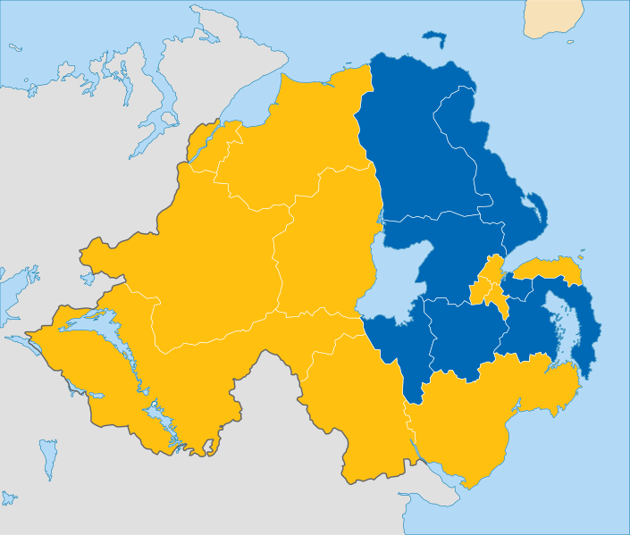
English: Results of the European Union membership referendum, 2016 in the Northern Ireland region.
Remain
Leave |
||
| Päiväys | |||
| Lähde | This work is derived from File:Northern Ireland location map.svg by NordNordWest (which contains United States National Imagery and Mapping Agency data). The style of the map is adapded to that of the other referendum results maps | ||
| Tekijä | Furfur | ||
| Käyttöoikeus (Tämän tiedoston uudelleenkäyttö) |
Minä, tämän teoksen tekijänoikeuksien haltija, julkaisen täten tämän teoksen seuraavilla lisensseillä:
Tämä tiedosto on lisensoitu Creative Commons Nimeä-JaaSamoin 4.0 Kansainvälinen -lisenssillä.
Voit valita haluamasi lisenssin. |

Tiedoston historia
Päiväystä napsauttamalla näet, millainen tiedosto oli kyseisellä hetkellä.
| Päiväys | Pienoiskuva | Koko | Käyttäjä | Kommentti | |
|---|---|---|---|---|---|
| nykyinen | 26. tammikuuta 2019 kello 14.49 | | 1 208 × 1 027 (95 KiB) | YourGloriousLeader | Minified version 67% smaller |
| 26. lokakuuta 2016 kello 11.30 |  | 1 208 × 1 027 (182 KiB) | Nilfanion | Reverted, per COM:OVERWRITE substantial changes should be as a new file | |
| 15. lokakuuta 2016 kello 04.17 |  | 1 208 × 1 027 (204 KiB) | Renamed user OCfxJKu7j2 | Added scale | |
| 24. kesäkuuta 2016 kello 10.03 |  | 1 208 × 1 027 (182 KiB) | EmmaCoop | Update | |
| 23. kesäkuuta 2016 kello 14.48 |  | 1 208 × 1 027 (123 KiB) | Furfur | corrected the constituency borders | |
| 23. kesäkuuta 2016 kello 12.38 |  | 1 208 × 1 027 (171 KiB) | Furfur | adjusted borderlines | |
| 23. kesäkuuta 2016 kello 12.34 |  | 1 208 × 1 027 (168 KiB) | Furfur | =={{int:filedesc}}== {{Information |description={{en|1=Results of the European Union membership referendum, 2016 in the Northern Ireland region.}} |date=2016-06-23 |source=This work is derived from File:Northern Ireland location map.svg by {{U|Nor... |
Tiedoston käyttö
Seuraava sivu käyttää tätä tiedostoa:
Tiedoston järjestelmänlaajuinen käyttö
Seuraavat muut wikit käyttävät tätä tiedostoa:
- Käyttö kohteessa cy.wikipedia.org
- Käyttö kohteessa de.wikipedia.org
- Käyttö kohteessa el.wikipedia.org
- Käyttö kohteessa en.wikipedia.org
- Käyttö kohteessa ko.wikipedia.org
- Käyttö kohteessa pl.wikipedia.org
- Käyttö kohteessa pt.wikipedia.org
.svg)