Tiedosto:UNRWA Fields of Operations Map 2017.pdf

Alkuperäinen tiedosto (1 793 × 2 502 kuvapistettä, 732 KiB, MIME-tyyppi: application/pdf)
| Tämä tiedosto on tiedostotietokanta Wikimedia Commonsista. Tiedot kuvaussivulta näkyvät alla. |  |
Tiedoston kuvaussivu Commonsissa |
Yhteenveto
| Kuvaus |
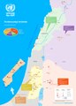
English: A map of the fields of operations of UNRWA, as of 1 January 2017 |
| Päiväys | |
| Lähde | United Nations Relief and Works Agency for Palestine Refugees in the Near East: Source |
| Tekijä | United Nations Relief and Works Agency for Palestine Refugees in the Near East, United Nations |
| Muut versiot |
|
Lisenssi
| This image is a map derived from a United Nations map.
Unless stated otherwise, UN maps are to be considered in the public domain. This applies worldwide. UN maps are, in principle, open source material and you can use them in your work or for making your own map. UN requests however that you delete the UN name, logo and reference number upon any modification to the map. Content of your map will be your responsibility. You can state in your publication, if you wish, something like: based on UN map … (map name, map number, revision number and date). See: Geospatial Information Section. And: Geospatial, location data for a better world. |
 |
Tiedoston historia
Päiväystä napsauttamalla näet, millainen tiedosto oli kyseisellä hetkellä.
| Päiväys | Pienoiskuva | Koko | Käyttäjä | Kommentti | |
|---|---|---|---|---|---|
| nykyinen | 16. joulukuuta 2018 kello 23.45 | 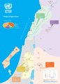 | 1 793 × 2 502 (732 KiB) | Jesuiseduardo | User created page with UploadWizard |
Tiedoston käyttö
Seuraava sivu käyttää tätä tiedostoa:
Tiedoston järjestelmänlaajuinen käyttö
Seuraavat muut wikit käyttävät tätä tiedostoa:
- Käyttö kohteessa bn.wikipedia.org
- Käyttö kohteessa en.wikipedia.org
- Käyttö kohteessa eo.wikipedia.org
- Käyttö kohteessa es.wikipedia.org
- Käyttö kohteessa fa.wikipedia.org
- Käyttö kohteessa fr.wikipedia.org
- Käyttö kohteessa id.wikipedia.org
- Käyttö kohteessa lt.wikipedia.org
- Käyttö kohteessa simple.wikipedia.org
- Käyttö kohteessa uz.wikipedia.org
- Käyttö kohteessa zh.wikipedia.org