Tiedosto:Stalingrad - Preparations for Operation Uranus.png
Tämän esikatselun koko: 800 × 492 kuvapistettä. Muut resoluutiot: 320 × 197 kuvapistettä | 640 × 394 kuvapistettä | 1 024 × 630 kuvapistettä | 1 280 × 788 kuvapistettä | 2 560 × 1 576 kuvapistettä | 4 321 × 2 660 kuvapistettä.
Alkuperäinen tiedosto (4 321 × 2 660 kuvapistettä, 2,83 MiB, MIME-tyyppi: image/png)
| Tämä tiedosto on tiedostotietokanta Wikimedia Commonsista. Tiedot kuvaussivulta näkyvät alla. |  |
Tiedoston kuvaussivu Commonsissa |

|
Tämä tyyppiä map oleva kuva pitäisi luoda uudelleen SVG-tiedostoksi vektorigrafiikan avulla. Tällä tiedostotyypillä on monia vahvuuksia, sivulta Commons:Media for cleanup löytyy lisätietoja. Jos tästä kuvasta on jo olemassa SVG-versio, ole ystävällinen ja tallenna se tänne. SVG-tiedoston tallentamisen jälkeen vaihda tämä malline mallineeseen {{vector version available|uusi kuvan nimi.svg}}.
|
Yhteenveto
| Kuvaus |
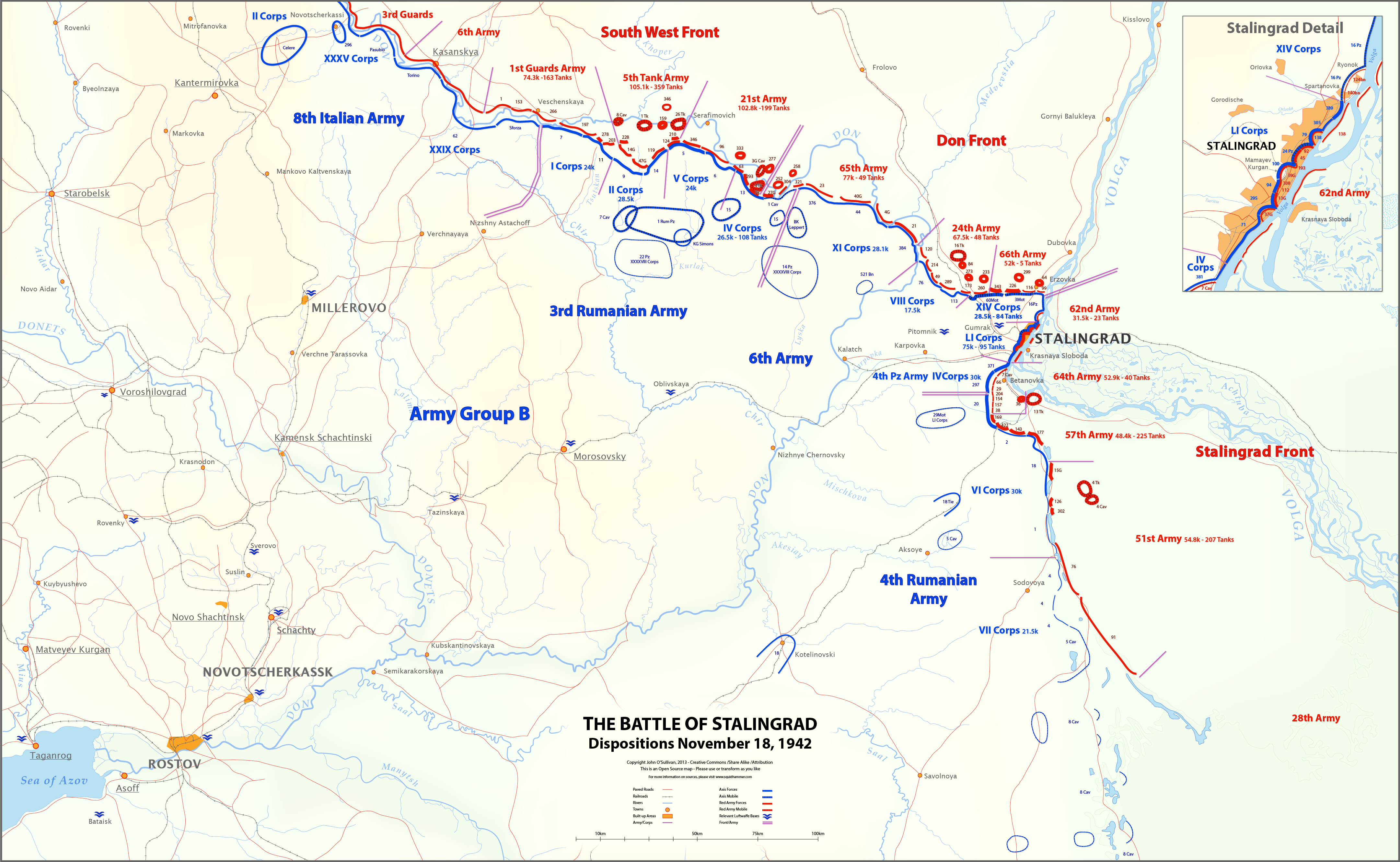
English: This map shows unit locations and relative strengths for Axis and Soviet Armies on Nov 18, 1942, during the Battle of Stalingrad.
On November 19, the Soviets launched Operation Uranus, an offensive designed to isolate and destroy the German 6th Army at Stalingrad. |
| Päiväys | |
| Lähde | Oma teos |
| Tekijä | Josullivan.59 |
| Muut versiot |
 |
Sources:
Books and Articles
| Author | Title | Notes |
| Alexei V. Isaev | Stalingrad: The Volga No Land For Us | Soviet forces and tanks |
| Antony Beevor | Stalingrad-The-Fateful-Siege-1942-1943 | Most widely cited Order of Battle |
| Wikipedia | Red Army Order of Battle Stalingrad | Useful |
| Wikipedia | Axis order of battle at the Battle of Stalingrad | Not particularly useful |
| Staldata | Staldata | Axis and Soviet Orders of Battle & force strength |
| Wolf Höpper | Against the Flood - Operation Uranus (I) | German tank numbers |
| Joel S. A. Hayward | Stopped At Stalingrad: The Luftwaffe And Hitler's Defeat In The East 1942-1943 | Bases used for Airlift |
| Akhil Kadidal | Stalingrad Pocket | Really good maps and annotated photographs |
Maps
| Title | Source | Notes |
| OKH Situation Map Nov 18 42 | WW2 Photos Maps | Axis forces locations Fantastic Site! |
| OKH Situation Map Nov 18 42 2 | WW2 Photos Maps | Axis forces locations Fantastic Site! |
| S4231 Summary of combat operations in Stalingrad | Armchair General/RIIAWW2 | Red Army locations Excellent map |
| S4239 Operations in Stalingrad area | RIIAWW2 Armchair General/RIIAWW2 | Red Army locations |
| S4251 Combat operations of the South-Western, Don and Stalingrad Fronts | Armchair General/RIIAWW2 | Red Army locations |
Notes:
- My Order of Battle is here.
- There are more units listed in the Order of Battle than appear on the map. I didn't place any unit on the map unless I could find it in one of the source maps.
- In conflicts between locations on the OKH map and the Soviet maps, I used the Soviet map. The Germans had not picked up the Uranus build-up, so the Soviets had much better intelligence at this time.
- I could find no information on the strength of the 8th Italian Army, or Soviet 6th and 3rd Guards Armies.
- Unit lines are thicker or thinner based on strength and density. These are characterizations, not precise measurements.
- Unit strengths are shown in the layers in the SVG version of the map. These are based on the Order of Battle spreadsheet linked above. The spreadsheet includes notes on the units shown on the map.
- The base map is derived from the OKH maps. I do not know the map projection.
- Please feel free to comment on any inaccuracies! You can help to make the map better. I'm particularly interested in proper place-names.
- Voit:
- jakaa – kopioida, levittää ja esittää teosta
- remiksata – valmistaa muutettuja teoksia
- Seuraavilla ehdoilla:
- nimeäminen – Sinun on mainittava lähde asianmukaisesti, tarjottava linkki lisenssiin sekä merkittävä, mikäli olet tehnyt muutoksia. Voit tehdä yllä olevan millä tahansa kohtuullisella tavalla, mutta et siten, että annat ymmärtää lisenssinantajan suosittelevan sinua tai teoksen käyttöäsi.
- jaa samoin – Jos muutat tai perustat tähän työhön, voit jakaa tuloksena syntyvää työtä vain tällä tai tämän kaltaisella lisenssillä.
Lisenssi
Minä, tämän teoksen tekijänoikeuksien haltija, julkaisen täten tämän teoksen seuraavalla lisenssillä:
Tämä tiedosto on lisensoitu Creative Commons Nimeä-JaaSamoin 3.0 Ei sovitettu -lisenssillä.
Tiedoston historia
Päiväystä napsauttamalla näet, millainen tiedosto oli kyseisellä hetkellä.
| Päiväys | Pienoiskuva | Koko | Käyttäjä | Kommentti | |
|---|---|---|---|---|---|
| nykyinen | 12. maaliskuuta 2013 kello 21.27 | | 4 321 × 2 660 (2,83 MiB) | Josullivan.59 | Fixed the licensing information on the map. |
| 12. maaliskuuta 2013 kello 21.13 |  | 4 322 × 2 660 (3,89 MiB) | Josullivan.59 | User created page with UploadWizard |
Tiedoston käyttö
Seuraava sivu käyttää tätä tiedostoa:
Tiedoston järjestelmänlaajuinen käyttö
Seuraavat muut wikit käyttävät tätä tiedostoa:
- Käyttö kohteessa de.wikipedia.org
- Käyttö kohteessa en.wikipedia.org
- Käyttö kohteessa es.wikipedia.org
- Käyttö kohteessa fr.wikipedia.org
- Käyttö kohteessa ja.wikipedia.org
- Käyttö kohteessa no.wikipedia.org
- Käyttö kohteessa pt.wikipedia.org
- Käyttö kohteessa uk.wikipedia.org