Tiedosto:Ocean currents 1943 (borderless)3.png

Tämän esikatselun koko: 800 × 405 kuvapistettä. Muut resoluutiot: 320 × 162 kuvapistettä | 640 × 324 kuvapistettä | 1 024 × 519 kuvapistettä | 1 280 × 649 kuvapistettä | 2 577 × 1 306 kuvapistettä.
Alkuperäinen tiedosto (2 577 × 1 306 kuvapistettä, 2,41 MiB, MIME-tyyppi: image/png)
| Tämä tiedosto on tiedostotietokanta Wikimedia Commonsista. Tiedot kuvaussivulta näkyvät alla. | 3.png?uselang=fi) |
Tiedoston kuvaussivu Commonsissa |

|
Tämä tyyppiä meteorology oleva kuva pitäisi luoda uudelleen SVG-tiedostoksi vektorigrafiikan avulla. Tällä tiedostotyypillä on monia vahvuuksia, sivulta Commons:Media for cleanup löytyy lisätietoja. Jos tästä kuvasta on jo olemassa SVG-versio, ole ystävällinen ja tallenna se tänne. SVG-tiedoston tallentamisen jälkeen vaihda tämä malline mallineeseen {{vector version available|uusi kuvan nimi.svg}}.
|
Yhteenveto
| Kuvaus |
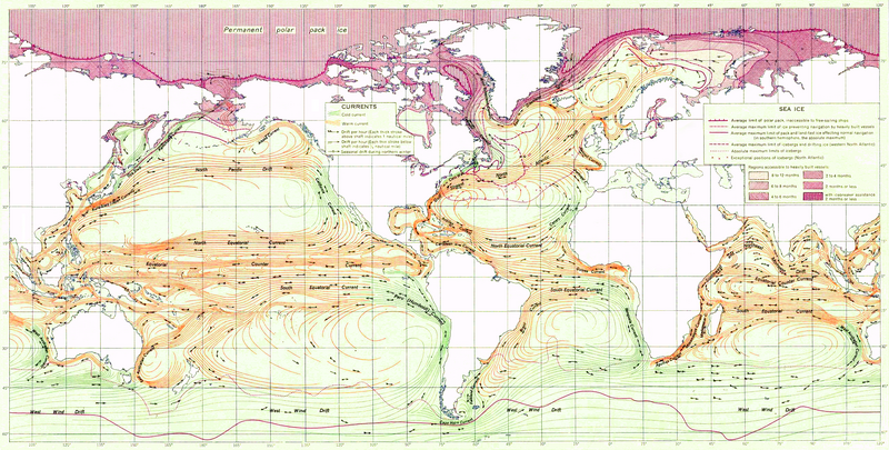
English: Ocean Currents and Sea Ice from Atlas of World Maps, United States Army Service Forces, Army Specialized Training Division. Army Service Forces Manual M-101 (1943).
Türkçe: Dünyanın büyük akıntılarının şeması |
|||
| Päiväys | ||||
| Lähde | Edited version of File:Ocean currents 1943 (borderless).png | |||
| Tekijä | US army | |||
| Käyttöoikeus (Tämän tiedoston uudelleenkäyttö) |
|
|||
| Muut versiot |
Tämä tiedosto on johdettu tiedostosta: Ocean currents 1943 (borderless).png (For more versions see there) |

.png)
.png)
| Tämän kuvan originaalia on jälkikäsitelty digitaalisesti. Muutokset: landmass interiors clarified, some latitude and longitude lines repaired, bottom longitudinal numbering replaced, and a stray pencil mark through the Indian Ocean removed. Originaali: Ocean currents 1943 (borderless).png. Muokkaaja: Jrockley.
|
Arviointi
|
3.png)
Tiedoston historia
Päiväystä napsauttamalla näet, millainen tiedosto oli kyseisellä hetkellä.
| Päiväys | Pienoiskuva | Koko | Käyttäjä | Kommentti | |
|---|---|---|---|---|---|
| nykyinen | 3. helmikuuta 2012 kello 00.18 | | 2 577 × 1 306 (2,41 MiB) | Mahahahaneapneap | Compressed again. Please don't revert unless you can give a reason why. |
| 20. tammikuuta 2012 kello 00.48 |  | 2 577 × 1 306 (3,4 MiB) | The ed17 | there is no reason to compress this | |
| 24. joulukuuta 2011 kello 21.27 |  | 2 577 × 1 306 (2,41 MiB) | Mahahahaneapneap | Compressed. Identical image, 1 MB smaller. | |
| 4. syyskuuta 2009 kello 17.34 |  | 2 577 × 1 306 (3,4 MiB) | Durova | Reverted to version as of 08:15, 27 June 2008 reverting arbitrary compression | |
| 17. lokakuuta 2008 kello 23.54 |  | 2 577 × 1 306 (2,41 MiB) | Mahahahaneapneap | Compressed | |
| 27. kesäkuuta 2008 kello 11.15 |  | 2 577 × 1 306 (3,4 MiB) | Durova | {{Information |Description=''Ocean Currents and Sea Ice from Atlas of World Maps'', United States Army Service Forces, Army Specialized Training Division. Army Service Forces Manual M-101 (1943). |Source=http://www.lib.utexas.edu/maps/world_maps/ocean |
Tiedoston käyttö
Tätä tiedostoa ei käytetä millään sivulla.
Tiedoston järjestelmänlaajuinen käyttö
Seuraavat muut wikit käyttävät tätä tiedostoa:
- Käyttö kohteessa ar.wikipedia.org
- Käyttö kohteessa ast.wikipedia.org
- Käyttö kohteessa az.wikipedia.org
- Käyttö kohteessa be.wikipedia.org
- Käyttö kohteessa bg.wikipedia.org
- Käyttö kohteessa bn.wikipedia.org
- Käyttö kohteessa ca.wikipedia.org
- Käyttö kohteessa da.wikipedia.org
- Käyttö kohteessa el.wikipedia.org
- Käyttö kohteessa en.wikipedia.org
- Ocean current
- Portal:Maps/Selected picture
- History of navigation
- Wikipedia:Featured pictures thumbs/12
- Wikipedia:Featured pictures/Diagrams, drawings, and maps/Maps
- User:Shoemaker's Holiday
- Wikipedia:Featured picture candidates/File:Ocean currents 1943 (borderless)3.png
- Wikipedia:Featured picture candidates/July-2008
- Wikipedia:Wikipedia Signpost/2008-07-07/Features and admins
- User talk:Durova/Archive 60
- Wikipedia:Wikipedia Signpost/2008-08-25/Features and admins
- Wikipedia:Wikipedia Signpost/2008-08-25/SPV
- Wikipedia:Wikipedia Signpost/2008-07-07/SPV
- Portal:Maps/Selected picture/37
- User talk:Shoemaker's Holiday/Archive 2
- Flow map
- Wikipedia:Picture of the day/January 2009
- Template:POTD/2009-01-05
- User talk:Durova/Archive 64
- User:Adam Cuerden
- User:Durova/Featured picture gallery/2008
- Wikipedia:WikiProject United States/Recognized content
- Wikipedia:WikiProject United States/Quality content
- Wikipedia:WikiProject United States/Featured pictures
- Wikipedia:Wikipedia Signpost/Single/2008-07-07
- Wikipedia:Wikipedia Signpost/Single/2008-08-25
- Käyttö kohteessa es.wikipedia.org
- Käyttö kohteessa fa.wikipedia.org
- Käyttö kohteessa hi.wikipedia.org
- Käyttö kohteessa hu.wikipedia.org
- Käyttö kohteessa ka.wikipedia.org
- Käyttö kohteessa lv.wikipedia.org
- Käyttö kohteessa mr.wikipedia.org
- Käyttö kohteessa oc.wikipedia.org
3.png)
Näytä lisää tämän tiedoston järjestelmänlaajuista käyttöä.
3.png)
3.png)