Tiedosto:Mingachevir Reservoir, Azerbaijan.JPG

Tämän esikatselun koko: 398 × 599 kuvapistettä. Muut resoluutiot: 159 × 240 kuvapistettä | 319 × 480 kuvapistettä | 510 × 768 kuvapistettä | 680 × 1 024 kuvapistettä | 1 361 × 2 048 kuvapistettä | 2 829 × 4 256 kuvapistettä.
Alkuperäinen tiedosto (2 829 × 4 256 kuvapistettä, 2,08 MiB, MIME-tyyppi: image/jpeg)
| Tämä tiedosto on tiedostotietokanta Wikimedia Commonsista. Tiedot kuvaussivulta näkyvät alla. |  |
Tiedoston kuvaussivu Commonsissa |
Yhteenveto
| Kuvaus |
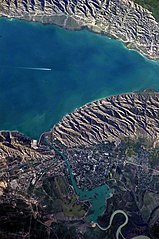
English: This detailed astronaut photograph highlights the southern Mingachevir Reservoir in north-central Azerbaijan. Folded layers of relatively young (less than 5. 3 million years old) sedimentary rock, explosive volcanic products (ash and tuff), and unconsolidated sediments form the grey hills along the northern and southern shorelines of the reservoir (image centre and right). Afternoon sun highlights distinctive parallel patterns in the hills that are the result of water and wind erosion of different rock layers exposed at the surface. The nearby city of Mingachevir (left) is split by the Kur River after it passes through the dam and hydroelectric power station complex at image top centre. The reservoir held approximately 15 billion cubic meters of water at the time this image was taken, with a total engineered capacity of 16 billion cubic meters. The width of the reservoir illustrated here is approximately 8 kilometres; a jet flying over the reservoir left a contrail midway between the shorelines. |
| Päiväys | |
| Lähde | NASA Earth Observatory |
| Tekijä | ISS Expedition 23 crew |
| Kameran sijainti | | Tämä ja muut kuvat kartalla: OpenStreetMap |
|---|
This image or video was catalogued by Johnson Space Center of the United States National Aeronautics and Space Administration (NASA) under Photo ID: ISS023-E-35670. This tag does not indicate the copyright status of the attached work. A normal copyright tag is still required. See Commons:Licensing. Other languages:
|
Image captured with a Nikon D3S digital camera, and is provided by the ISS Crew Earth Observations experiment and Image Science & Analysis Laboratory, Johnson Space Center.
Lisenssi
| Tämä teos on ilman tekijänoikeuden suojaa, koska National Aeronautics and Space Administration (NASA) loi sen. Koska Nasa on Yhdysvaltain liittovaltion organisaatio, sen luomat teokset ovat ilman tekijänoikeuden suojaa. ([1][2]) | ||
 |
Varoitukset:
|
| Annotations | This image is annotated: View the annotations at Commons |
Tiedoston historia
Päiväystä napsauttamalla näet, millainen tiedosto oli kyseisellä hetkellä.
| Päiväys | Pienoiskuva | Koko | Käyttäjä | Kommentti | |
|---|---|---|---|---|---|
| nykyinen | 18. kesäkuuta 2018 kello 13.00 | | 2 829 × 4 256 (2,08 MiB) | SteinsplitterBot | Bot: Image rotated by 270° |
| 7. kesäkuuta 2010 kello 19.54 |  | 4 256 × 2 829 (2,09 MiB) | Originalwana | {{Information |Description={{en|1=This detailed astronaut photograph highlights the southern Mingachevir Reservoir in north-central Azerbaijan. Folded layers of relatively young (less than 5. 3 million years old) sedimentary rock, explosive volcanic p |
Tiedoston käyttö
Seuraava sivu käyttää tätä tiedostoa:
Tiedoston järjestelmänlaajuinen käyttö
Seuraavat muut wikit käyttävät tätä tiedostoa:
- Käyttö kohteessa arz.wikipedia.org
- Käyttö kohteessa azb.wikipedia.org
- Käyttö kohteessa az.wikipedia.org
- Käyttö kohteessa az.wiktionary.org
- Käyttö kohteessa be.wikipedia.org
- Käyttö kohteessa ca.wikipedia.org
- Käyttö kohteessa ceb.wikipedia.org
- Käyttö kohteessa cs.wikipedia.org
- Käyttö kohteessa de.wikipedia.org
- Käyttö kohteessa en.wikipedia.org
- Käyttö kohteessa eo.wikipedia.org
- Käyttö kohteessa es.wikipedia.org
- Käyttö kohteessa fa.wikipedia.org
- Käyttö kohteessa fr.wikipedia.org
- Käyttö kohteessa fy.wikipedia.org
- Käyttö kohteessa he.wikipedia.org
- Käyttö kohteessa hr.wikipedia.org
- Käyttö kohteessa hu.wikipedia.org
- Käyttö kohteessa hy.wikipedia.org
- Käyttö kohteessa id.wikipedia.org
- Käyttö kohteessa ilo.wikipedia.org
- Käyttö kohteessa it.wikipedia.org
- Käyttö kohteessa ja.wikipedia.org
Näytä lisää tämän tiedoston järjestelmänlaajuista käyttöä.