Tiedosto:Map of Oregon NA.png

Tämän esikatselun koko: 800 × 541 kuvapistettä. Muut resoluutiot: 320 × 217 kuvapistettä | 640 × 433 kuvapistettä | 1 024 × 693 kuvapistettä | 1 280 × 866 kuvapistettä | 1 967 × 1 331 kuvapistettä.
Alkuperäinen tiedosto (1 967 × 1 331 kuvapistettä, 2,15 MiB, MIME-tyyppi: image/png)
| Tämä tiedosto on tiedostotietokanta Wikimedia Commonsista. Tiedot kuvaussivulta näkyvät alla. |  |
Tiedoston kuvaussivu Commonsissa |
Yhteenveto
| Kuvaus |
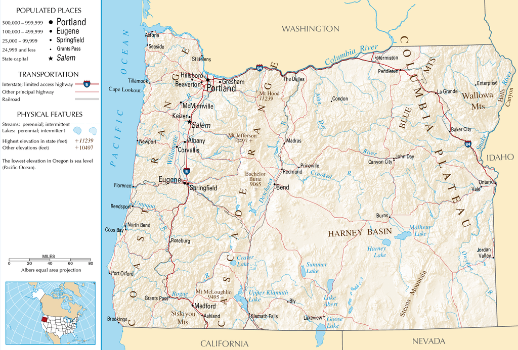
English: Topographic map of the geography of Oregon — with major rivers shown.
|
| Lähde | National Atlas |
| Tekijä | Tuntematon |
Lisenssi
This map was obtained from an edition of the National Atlas of the United States. Like almost all works of the U.S. federal government, works from the National Atlas are in the public domain in the United States.
Online access: NationalAtlas.gov | 1970 print edition: Library of Congress, Perry-Castañeda Library
|
Tiedoston historia
Päiväystä napsauttamalla näet, millainen tiedosto oli kyseisellä hetkellä.
| Päiväys | Pienoiskuva | Koko | Käyttäjä | Kommentti | |
|---|---|---|---|---|---|
| nykyinen | 16. lokakuuta 2007 kello 08.46 | | 1 967 × 1 331 (2,15 MiB) | Peteforsyth | removed extraneous text and logo from public domain image |
| 15. elokuuta 2006 kello 11.13 |  | 2 122 × 1 640 (2,75 MiB) | Huebi~commonswiki | {{Information| |Description=Map of Oregon |Source=[http://www.nationalatlas.gov National Atlas] }} Category:Maps of the United States Category:Maps of Oregon {{PD-USGov-Atlas}} |
Tiedoston käyttö
Seuraava sivu käyttää tätä tiedostoa:
Tiedoston järjestelmänlaajuinen käyttö
Seuraavat muut wikit käyttävät tätä tiedostoa:
- Käyttö kohteessa als.wikipedia.org
- Käyttö kohteessa ar.wikipedia.org
- Käyttö kohteessa de.wikipedia.org
- Käyttö kohteessa en.wikipedia.org
- Käyttö kohteessa eo.wikipedia.org
- Käyttö kohteessa fr.wikipedia.org
- Käyttö kohteessa hr.wiktionary.org
- Käyttö kohteessa hsb.wikipedia.org
- Käyttö kohteessa hu.wikipedia.org
- Käyttö kohteessa incubator.wikimedia.org
- Käyttö kohteessa is.wikipedia.org
- Käyttö kohteessa it.wikipedia.org
- Käyttö kohteessa ja.wikipedia.org
- Käyttö kohteessa kk.wikipedia.org
- Käyttö kohteessa lt.wikipedia.org
- Käyttö kohteessa mr.wikipedia.org
- Käyttö kohteessa nds-nl.wikipedia.org
- Käyttö kohteessa pa.wikipedia.org
- Käyttö kohteessa ru.wikipedia.org
- Käyttö kohteessa sw.wikipedia.org
- Käyttö kohteessa vi.wikipedia.org
- Käyttö kohteessa zea.wikipedia.org