Tiedosto:Grand Canyon Indians.png

Tämän esikatselun koko: 511 × 600 kuvapistettä. Muut resoluutiot: 204 × 240 kuvapistettä | 409 × 480 kuvapistettä | 654 × 768 kuvapistettä | 872 × 1 024 kuvapistettä | 1 582 × 1 857 kuvapistettä.
Alkuperäinen tiedosto (1 582 × 1 857 kuvapistettä, 3,28 MiB, MIME-tyyppi: image/png)
| Tämä tiedosto on tiedostotietokanta Wikimedia Commonsista. Tiedot kuvaussivulta näkyvät alla. |  |
Tiedoston kuvaussivu Commonsissa |
| Kuvaus |
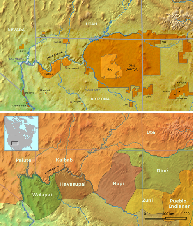
Map of Native American tribes in Arizona — located in the Grand Canyon and Northern Arizona regions.
|
||||
| Päiväys | |||||
| Lähde | Own work by Nikater, submitted to the public domain. Background map courtesy of Demis, www.demis.nl | ||||
| Tekijä | User:Nikater | ||||
| Käyttöoikeus (Tämän tiedoston uudelleenkäyttö) |
|
Tiedoston historia
Päiväystä napsauttamalla näet, millainen tiedosto oli kyseisellä hetkellä.
| Päiväys | Pienoiskuva | Koko | Käyttäjä | Kommentti | |
|---|---|---|---|---|---|
| nykyinen | 27. elokuuta 2015 kello 16.23 | | 1 582 × 1 857 (3,28 MiB) | RokerHRO | optipng -i0 -zc1-9 -zm1-9 -zs0-3 -f0-5 -i0 → 10.21% decrease |
| 18. marraskuuta 2007 kello 20.13 |  | 1 582 × 1 857 (3,65 MiB) | Nikater | {{Information |Description=Map of traditional Indian tribal territories and reservations in the Grand Canyon area. |Source=Own work by Nikater, submitted to the public domain. Background map courtesy of Demis, www.demis.nl |Date=18 November 2007 |Author=[ |
Tiedoston käyttö
Seuraava sivu käyttää tätä tiedostoa:
Tiedoston järjestelmänlaajuinen käyttö
Seuraavat muut wikit käyttävät tätä tiedostoa:
- Käyttö kohteessa bg.wikipedia.org
- Käyttö kohteessa da.wikipedia.org
- Käyttö kohteessa de.wikipedia.org
- Käyttö kohteessa en.wikipedia.org
- Käyttö kohteessa eo.wikipedia.org
- Käyttö kohteessa he.wikipedia.org
- Käyttö kohteessa nl.wikipedia.org
- Käyttö kohteessa no.wikipedia.org