Tiedosto:First Republic of Armenia in 1918-1920.png

Tämän esikatselun koko: 799 × 348 kuvapistettä. Muut resoluutiot: 320 × 139 kuvapistettä | 640 × 279 kuvapistettä | 1 024 × 446 kuvapistettä | 1 280 × 558 kuvapistettä | 2 560 × 1 115 kuvapistettä | 8 192 × 3 568 kuvapistettä.
Alkuperäinen tiedosto (8 192 × 3 568 kuvapistettä, 14,85 MiB, MIME-tyyppi: image/png)
| Tämä tiedosto on tiedostotietokanta Wikimedia Commonsista. Tiedot kuvaussivulta näkyvät alla. |  |
Tiedoston kuvaussivu Commonsissa |
Yhteenveto
| Kuvaus |
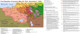
English: The First Republic of Armenia in 1918-1920. |
| Päiväys | |
| Lähde | Oma teos |
| Tekijä | Accipite7 |
Lisenssi
Minä, tämän teoksen tekijänoikeuksien haltija, julkaisen täten tämän teoksen seuraavalla lisenssillä:
Tämä tiedosto on lisensoitu Creative Commons Nimeä-JaaSamoin 4.0 Kansainvälinen -lisenssillä.
- Voit:
- jakaa – kopioida, levittää ja esittää teosta
- remiksata – valmistaa muutettuja teoksia
- Seuraavilla ehdoilla:
- nimeäminen – Sinun on mainittava lähde asianmukaisesti, tarjottava linkki lisenssiin sekä merkittävä, mikäli olet tehnyt muutoksia. Voit tehdä yllä olevan millä tahansa kohtuullisella tavalla, mutta et siten, että annat ymmärtää lisenssinantajan suosittelevan sinua tai teoksen käyttöäsi.
- jaa samoin – Jos muutat tai perustat tähän työhön, voit jakaa tuloksena syntyvää työtä vain tällä tai tämän kaltaisella lisenssillä.
Tiedoston historia
Päiväystä napsauttamalla näet, millainen tiedosto oli kyseisellä hetkellä.
| Päiväys | Pienoiskuva | Koko | Käyttäjä | Kommentti | |
|---|---|---|---|---|---|
| nykyinen | 2. kesäkuuta 2021 kello 18.13 | | 8 192 × 3 568 (14,85 MiB) | Accipite7 | for the convenience of viewing small details, the size is increased, the colors are improved |
| 25. toukokuuta 2021 kello 11.17 |  | 4 096 × 1 784 (3,69 MiB) | Accipite7 | The border between Nahang of Shirak and Nahang of Syunik has been clarified. | |
| 21. toukokuuta 2021 kello 12.59 |  | 4 096 × 1 784 (3,7 MiB) | Accipite7 | The temporary border between the Republic of Armenia and the Soviet republics (August 10, 1920) in the Nakhichevan county has been clarified. Added a legend marked on the map under the number 26. | |
| 13. toukokuuta 2021 kello 11.35 |  | 4 096 × 1 784 (3,97 MiB) | Accipite7 | fixed typo | |
| 13. toukokuuta 2021 kello 11.27 |  | 4 096 × 1 784 (3,97 MiB) | Accipite7 | The names of the types of administrative units of the former Russian Empire have been clarified: uyezd = county, okrug = district, oblast = territory, guberniya = governorate. | |
| 12. toukokuuta 2021 kello 14.14 |  | 4 096 × 1 784 (3,71 MiB) | Accipite7 | Corrected data in the map legend regarding what is indicated on the map by numbers. Clarified the boundaries of the territories required at the Paris Peace Conference. I strongly ask the user of Culminatio not to vandalize and not return the map to the version on which he marked the line reached as a result of the Turkish offensive in 1920. Since, firstly, it is neural: Batumi, Artvin and Ardahan were under the control of the Democratic Republic of Georgia until February-March 1921. And secon... | |
| 12. toukokuuta 2021 kello 07.13 |  | 5 375 × 2 341 (7,18 MiB) | Culminatio | Reverted to version as of 15:05, 8 May 2021 (UTC) | |
| 11. toukokuuta 2021 kello 10.11 |  | 4 096 × 1 784 (3,99 MiB) | Accipite7 | The boundaries of the territory of the demands of the Armenian delegation in the Transcaucasus, submitted to the Paris Peace Conference of 1919, were clarified. There is no need to overload the map with the line reached by the Turkish forces in 1920, as the map already shows the results of the Armenian-Turkish war of 1920 - the border according to the Treaty of Alexandropol, December 2, 1920 | |
| 8. toukokuuta 2021 kello 18.05 |  | 5 375 × 2 341 (7,18 MiB) | Culminatio | Additional line of the turkish advance on the northern positions during the war of 1920. Additional numbers 10,19,20,21 on the map. | |
| 8. toukokuuta 2021 kello 13.49 |  | 6 336 × 2 760 (2,21 MiB) | Accipite7 | Improved colors. |
Tiedoston käyttö
Seuraava sivu käyttää tätä tiedostoa:
Tiedoston järjestelmänlaajuinen käyttö
Seuraavat muut wikit käyttävät tätä tiedostoa:
- Käyttö kohteessa az.wikipedia.org
- Käyttö kohteessa be.wikipedia.org
- Käyttö kohteessa bg.wikipedia.org
- Käyttö kohteessa de.wikipedia.org
- Käyttö kohteessa el.wikipedia.org
- Käyttö kohteessa fr.wikipedia.org
- Käyttö kohteessa hy.wikipedia.org
- Käyttö kohteessa it.wikipedia.org
- Käyttö kohteessa nl.wikipedia.org
- Käyttö kohteessa pl.wikipedia.org
- Käyttö kohteessa pt.wikipedia.org
- Käyttö kohteessa ro.wikipedia.org
- Käyttö kohteessa ru.wikipedia.org
- Käyttö kohteessa sr.wikipedia.org
- Käyttö kohteessa uk.wikipedia.org
- Käyttö kohteessa zh.wikipedia.org