Alkuperäinen tiedosto(1 920 × 1 440 kuvapistettä, 1,41 MiB, MIME-tyyppi: image/jpeg)

Yhteenveto

Kuvaus
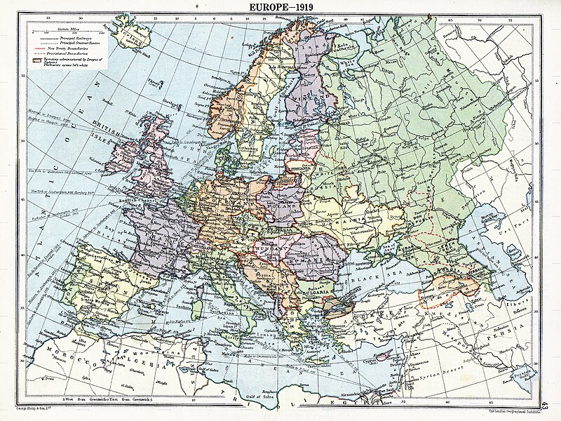
English: Map of en:Europe political divisions in 1919 (after the treaties of Brest-Litovsk and Versailles and before the treaties of Trianon, Riga, Kars and the establishment of en:Soviet Union and the republics of Ireland and Turkey) published by London Geographical Institute. This uploaded map is a photoshopped version of the original image located at hipkiss.org. According to the site, there are no copyrights to this map.
Lähde
Tekijä
Muut versiot Tämän tiedoston johdannaisteoksia:  Europe map 1919 cropped.JPG
Maps of the history of Europe
BCE
aC

Weichselian ice age (c. 113,000–9700) · Neolithic expansion (c. 7000–4500) · Middle Neolithic (c. 4500–4000) · Late Neolithic (c. 4000–3000) · Copper Age – Corded Ware culture (c. 2900–2350) · Copper Age – Bellbeaker culture (c. 2800–1800) · Early Bronze Age – Unetice culture (c. 2300–1600) · Late Bronze Age – Urnfield culture (c. 1300—750) · Migrations (c. 1000–100) · Hallstatt & La Tène cultures (c. 800–100) · Roman Republic (510–40) · 220 · 218 · 200 · 201–100 · 58 · 49 · 39 · 30 BCE–6 CE


CE
dC

14 · 14–37 · 60 · 60 · 69 · 80 · Migrations 100–500 · 117 · 117 · 125 · Migrations 150–774 · Economy 180 · 271 · 293–305 · 337 · 395 · c. 395 · 400 · 400 · 450 · 457–61 · 476 · 480 · Franks 481–814 · Early Slavs 500–700 · 500 · 526 · 526–600 · Christianisation to 600 · c. 550 · 650 · Pontic Steppe 650 · 665 · 800 · Vikings 800–1050 · 814 · 843–70 · 850 · 900 · 912 · 998 · 1000 · 1000 · 1054 · 1092 · First Crusade 1095–99 · 1097 · 1135 · 1142 · 1147–49 · 1190 · 1190 · 1250 · c. 1250 · 1301-1400 · 1301-1400 · 1328 · 1345 · Black Plague 1347–51 · 1360 · 1400 · Trade routes c. 1400 · 1430 · 1470 · 1490 · 1492 · 1500 · 1519 · 1550 · 1560 · Religion 1560 · Religion 1600 · Religion 1618 · 1618–48 · 1648 · 1683 · 1700 · 1701 · 1708 · 1714 · 1721 · 1725–30 · 1739–1740 · 1740 · 1748–66 · 1783–1792 · 1787 · 1787 · 1789 · 1799 · 1812 · 1812 · 1812 · 1812 · 1813 · 1815 · 1815 · 1815 · 1818 · Ottoman Empire 1830–1923 · 1848–49 · 1861 · 1867 · 1871 · 1878 · 1890 · 1905 · 1911 · 1914 · 1914 · 1919 · 1919–29 · 1923 · 1929 · 1930 · 1940 · 1941–42 · 1942–45 · Cold War 1947–91 · 1950 · 1993–2006 · 2006 to date

(this template: · view · discuss )

Lisenssi

Public domain
Public domain
Tämä ennen vuotta 1929 julkaistu yhdysvaltalainen teos on ilman tekijänoikeuden suojaa Yhdysvalloissa. Ennen vuotta 1998 tekijänoikeuden suoja-aika oli ennen vuotta 1978 julkaistuille muodollisuudet (tekijänoikeushuomautus, ennen vuotta 1964 myös tekijänoikeuden uusiminen) täyttäneille teoksille 75 vuotta julkaisuvuodesta. Vuoden 1998 alussa näiden teosten suoja-aika pidennettiin 95 vuoteen julkaisuvuodesta. Ne teokset, jotka olivat ilman tekijänoikeuden suojaa vuoden 1998 alussa, eivät saaneet tekijänoikeuttaan takaisin, ja siten kaikki ennen vuotta 1929 julkaistut yhdysvaltalaiset teokset ovat ilman tekijänoikeuden suojaa.

United States
United States
Tämä teos saattaa olla yhä tekijänoikeuden alainen sellaisilla hallinnollisilla alueilla, jotka eivät hyväksy lyhyempää suoja-aikaa yhdysvaltalaisille teoksille. Tällaisia alueita ovat muun muassa Kanada, Kiina (ei Hong Kong tai Macao), Meksiko, Saksa ja Sveitsi. Lataajalle: Mainitse teoksen tekijä ja julkaisuvuosi.

Alkuperäinen tallennusloki

Alkuperäinen kuvaussivu oli täällä. Käyttäjätunnukset alla viittaavat kohteeseen en.wikipedia.
  • 2007-11-03 20:09 MaGioZal 1996×1506×8 (1457003 bytes) Map of [[Europe]] political divisions in 1919 (after the treaties of [[Treaty_of_Brest-Litovsk|Brest-Livotsk]] and [[Treaty of Versailles|Versailles]] and before the [[Treaty of Riga]] and the creation of [[Soviet Union]]) published by London Geographical

Kuvatekstit

Lisää yhden rivin pituinen kuvaus tästä tiedostosta
The situation in Europe after WW1. Several new states were born such as Ukraine(the country in Yellow at the North of the Black Sea)

Kohteet, joita tässä tiedostossa esitetään

esittää

image/jpeg

Tiedoston historia

Päiväystä napsauttamalla näet, millainen tiedosto oli kyseisellä hetkellä.

PäiväysPienoiskuvaKokoKäyttäjäKommentti
nykyinen7. elokuuta 2023 kello 08.41Pienoiskuva 7. elokuuta 2023 kello 08.41 tallennetusta versiosta1 920 × 1 440 (1,41 MiB)User-duckCropped to reduce border using CropTool with lossless mode.
23. huhtikuuta 2008 kello 02.29Pienoiskuva 23. huhtikuuta 2008 kello 02.29 tallennetusta versiosta1 996 × 1 506 (1,39 MiB)File Upload Bot (Magnus Manske) {{BotMoveToCommons|en.wikipedia}} {{Information |Description={{en|Map of en:Europe political divisions in 1919 (after the treaties of Brest-Livotsk and Versailles and before the treaties o

Seuraava sivu käyttää tätä tiedostoa:

Tiedoston järjestelmänlaajuinen käyttö

Seuraavat muut wikit käyttävät tätä tiedostoa:

Näytä lisää tämän tiedoston järjestelmänlaajuista käyttöä.