Tiedosto:CIS (orthographic projection).svg

Tämän PNG-esikatselun koko koskien SVG-tiedostoa: 541 × 541 kuvapistettä. Muut resoluutiot: 240 × 240 kuvapistettä | 480 × 480 kuvapistettä | 768 × 768 kuvapistettä | 1 024 × 1 024 kuvapistettä | 2 048 × 2 048 kuvapistettä.
Alkuperäinen tiedosto (SVG-tiedosto; oletustarkkuus 541 × 541 kuvapistettä; tiedostokoko 558 KiB)
| Tämä tiedosto on tiedostotietokanta Wikimedia Commonsista. Tiedot kuvaussivulta näkyvät alla. | .svg?uselang=fi) |
Tiedoston kuvaussivu Commonsissa |
Yhteenveto
| Kuvaus |
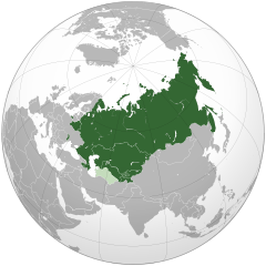
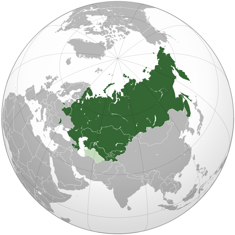
Čeština: Společenství nezávislých států
English: Orthographic projection of Commonwealth of Independent States.
Українська: Співдружність Незалежних Держав |
| Päiväys | |
| Lähde | Oma teos |
| Tekijä | Dag13 |
| SVG kehittely | Tämä vektorigrafiikkatiedosto luotiin käyttäen apuna ohjelmaa Inkscape. SVG watermarked with invisible embedded text. |
Lisenssi
| This map is ineligible for copyright and therefore in the public domain, because it consists entirely of information that is common property and contains no original authorship. For more information, see Commons:Threshold of originality § Maps.
|
Tiedoston historia
Päiväystä napsauttamalla näet, millainen tiedosto oli kyseisellä hetkellä.
.svg&dir=prev)
.svg&offset=&limit=20)
.svg&offset=&limit=50)
.svg&offset=&limit=100)
.svg&offset=&limit=250)
.svg&offset=&limit=500)
.svg&offset=20200121005429)
| Päiväys | Pienoiskuva | Koko | Käyttäjä | Kommentti | |
|---|---|---|---|---|---|
| nykyinen | 18. toukokuuta 2021 kello 23.45 | | 541 × 541 (558 KiB) | ThebeOkonma | Revert to correct version - Crimea is internationally recognised (e.g. by the UN) as part of Ukraine |
| 9. syyskuuta 2020 kello 19.34 |  | 541 × 541 (609 KiB) | Compu wiki | Reverted to version as of 15:04, 7 August 2020 (UTC) | |
| 2. syyskuuta 2020 kello 15.54 |  | 541 × 541 (558 KiB) | Goo3 | Well, it really does. Along with UN, NATO, USA, EU etc. | |
| 7. elokuuta 2020 kello 18.04 |  | 541 × 541 (609 KiB) | Compu wiki | Reverted to version as of 11:47, 15 July 2020 (UTC) The whole world does not recognize the territorial integrity of Ukraine. | |
| 29. heinäkuuta 2020 kello 19.33 |  | 541 × 541 (558 KiB) | Goo3 | Crimea is a globally recognized a a Ukrainian territory, which is not a member of this organization. Reverting to a correct version | |
| 15. heinäkuuta 2020 kello 14.47 |  | 541 × 541 (609 KiB) | Compu wiki | Reverted to version as of 13:02, 23 January 2020 (UTC) | |
| 14. heinäkuuta 2020 kello 14.53 |  | 541 × 541 (558 KiB) | Goo3 | Crimea is not disputed, it's annexed by Russia due to UN and recognizes as Ukraine by international law. Also, Ukraine is outside the CIS, uploaded a correct map. | |
| 23. tammikuuta 2020 kello 16.02 |  | 541 × 541 (609 KiB) | Rob984 | Reverted to version as of 20:53, 27 May 2018 (UTC) Ukraine has de facto quit. It is not an associate member, and does not participate in the organisation. | |
| 22. tammikuuta 2020 kello 18.47 |  | 541 × 541 (611 KiB) | Compu wiki | Reverted to version as of 07:09, 7 September 2019 (UTC) | |
| 21. tammikuuta 2020 kello 03.54 |  | 541 × 541 (609 KiB) | Homme | Reverted to version as of 05:40, 10 June 2018 (UTC) |
Tiedoston käyttö
Tätä tiedostoa ei käytetä millään sivulla.
Tiedoston järjestelmänlaajuinen käyttö
Seuraavat muut wikit käyttävät tätä tiedostoa:
- Käyttö kohteessa af.wikipedia.org
- Käyttö kohteessa als.wikipedia.org
- Käyttö kohteessa be-tarask.wikipedia.org
- Käyttö kohteessa be.wikipedia.org
- Käyttö kohteessa bn.wikipedia.org
- Käyttö kohteessa bxr.wikipedia.org
- Käyttö kohteessa cdo.wikipedia.org
- Käyttö kohteessa ckb.wikipedia.org
- Käyttö kohteessa cs.wikipedia.org
- Käyttö kohteessa en.wikipedia.org
- Käyttö kohteessa en.wikivoyage.org
- Käyttö kohteessa et.wikipedia.org
- Käyttö kohteessa he.wikipedia.org
- Käyttö kohteessa it.wikivoyage.org
- Käyttö kohteessa ja.wikipedia.org
- Käyttö kohteessa kk.wikipedia.org
- Käyttö kohteessa kw.wikipedia.org
- Käyttö kohteessa ky.wikipedia.org
- Käyttö kohteessa la.wikipedia.org
- Käyttö kohteessa lv.wikipedia.org
- Käyttö kohteessa mk.wikipedia.org
- Käyttö kohteessa nl.wikipedia.org
- Käyttö kohteessa pl.wikipedia.org
- Käyttö kohteessa pt.wikipedia.org
- Käyttö kohteessa ro.wikipedia.org
- Käyttö kohteessa ro.wikivoyage.org
- Käyttö kohteessa rue.wikipedia.org
- Käyttö kohteessa ru.wikipedia.org
- Käyttö kohteessa sco.wikipedia.org
- Käyttö kohteessa sd.wikipedia.org
- Käyttö kohteessa simple.wikipedia.org
- Käyttö kohteessa sk.wikipedia.org
- Käyttö kohteessa sq.wikipedia.org
Näytä lisää tämän tiedoston järjestelmänlaajuista käyttöä.
.svg)
.svg)